Plan in the appendices of the geographical location of the mountains. Plans for describing geographical objects material (geography) on the topic
The science of geography is not only concerned with the study of the natural features of various regions. A description of the country, its climate, population, economy and government structure is also among the subjects of research in this discipline. How are states studied? What does a country description plan look like? You will learn about this from our article.
How to describe a country?
Geographers describe countries in approximately the same way. It includes characteristics of nature, population, economy and government. The country description plan includes the following points:
- geographical location (territory area, length of borders, coordinates of extreme points, availability of access to the sea, number of neighboring countries and general assessment of the advantageousness of the geopolitical position of the state);
- natural features of the territory (climate, relief, internal waters, organic world, etc.);
- capital and administrative-territorial structure of the state;
- population of the country (total number, density, distribution, ethnic, religious and linguistic composition);
- the country's economy (main specialization, leading industries, level of agricultural development, volume and other economic indicators);
- features of the political structure (parliament, president, government).
A country description plan may also contain information about cultural characteristics, tourist attractions, currency, and official symbols of the state.
Geographical location of the country
Any plan for describing a country must begin with where that country is located. That is, it is necessary to provide information about in which hemisphere and on which continent the state is located, what its area is and the total length of the border. The coordinates of countries are determined by their extreme points: northern, southern, western and eastern. Based on this information, it is possible to determine the total length of the state’s territory from west to east, or from north to south, as well as evaluate its overall configuration (compact or elongated in a certain direction).
It is important not only to describe the geographical location of the country, but also to evaluate its economic benefits. Therefore, it is extremely important to indicate which states the country borders with, whether it has access to the sea, major navigable rivers, and whether it is located at the intersection of important transport corridors. Each of these aspects greatly affects the economy and overall well-being of the country.
Natural conditions and resources
The second point of the country description plan is the natural features of a particular territory (geomorphological, climatic, etc.).
A country's climate is extremely important for its economic development. Thus, the location of the state in a temperate climate zone (between 45 and 65 degrees) is considered ideal. This zone has the most optimal conditions for human life and farming.

The topography of a country also affects its well-being. It is no secret that on flat terrain it is much easier to build cities, lay roads, and create large industrial complexes. By the way, the most ancient and famous cities in the world arose precisely on the plains, near the shores of the seas or large rivers.
Population of the country
The population of a country is also an important aspect for its comprehensive study. When describing it, it is necessary to indicate the total number of inhabitants, population density, characterize the demographic situation, and so on.
Important indicators are mortality, life expectancy in the country, and the infant mortality rate. Most economically developed countries are characterized by low birth rates, low mortality rates and significant life expectancy. In contrast, developing countries in Asia, Africa and America experience high fertility, high mortality and low life expectancy.

An important aspect in the characteristics of any country is the ethnic, linguistic and religious composition of its population. All states of the world are divided into two groups: mono-ethnic (in which one nation predominates) and multi-ethnic (which are a kind of “mix” of ethnic groups and nationalities).
State Economy
The main indicators of economic development include the following:
- volumes of GDP and GNP per capita;
- income level of the population;
- competitiveness of goods and services produced in the country;
- cost and quality of labor;
- level of corruption;
- level of production modernization, etc.
According to these indicators, all countries of the world are divided into several groups. There are economically developed countries (Japan, USA, Canada, Australia, South Korea, Germany, France and others), developing countries (Myanmar, Chad, Bolivia, Bangladesh and others), as well as (Russia, Ukraine, Belarus, Kazakhstan, etc.). d.).
According to the structure of industrial production, all states are also divided into:
- industrial;
- agricultural;
- industrial-agrarian;
- post-industrial.
Political structure of the country
The state is a special organization with a complex structure that is designed to govern society. All countries of the world are usually divided into three groups:
- unitary - those that are controlled from one center (examples: Romania, Ukraine, France, Norway, etc.);
- federal, consisting of several separate entities - states, lands, republics (examples: Russia, USA, Germany);
- confederations are temporary unions of two or more states.

According to the form of government, countries are distinguished as monarchies (in which all power belongs to one person and is inherited) and republics (in which the main source of power is the majority). Monarchies can also be absolute (the monarch's power is unlimited), parliamentary (the monarch's power is limited by parliament) and theocratic (the supreme power belongs to the Church). The only modern example on the planet is the Vatican.
A country's policy is determined by the system of methods and techniques with the help of which it realizes the fullness of its power. Based on this thesis, the political regime of a particular state can be legal (democratic), totalitarian or authoritarian.
Countries and their capitals
The capital is the main (not necessarily the largest) city of the country, in which the government and other important government bodies are located. The word itself comes from the Old Russian “(pre)stol”, which means “throne”. The popular expression “capital city of Kyiv” is associated with this etymology.

Choosing a capital is always a dilemma for the state. After all, two or more large centers can lay claim to the role of the main city. In the Austro-Hungarian Empire, for example, they could not solve this problem. Therefore, there were two capitals there at once - Vienna and Budapest. In some states, the capital was created and built practically from scratch (an example of such a state would be the United States of America with its capital in Washington).
Countries and their capitals are often perceived as one whole. However, we should not forget that the title of “main city” in the state may change. So, in 1997, the Kazakh authorities moved the capital from Almaty to the city of Astana.
Another interesting capital on the world map is Jerusalem. This city is the capital of two countries at the same time - Israel and Palestine.
Flag - as the main symbol of the state
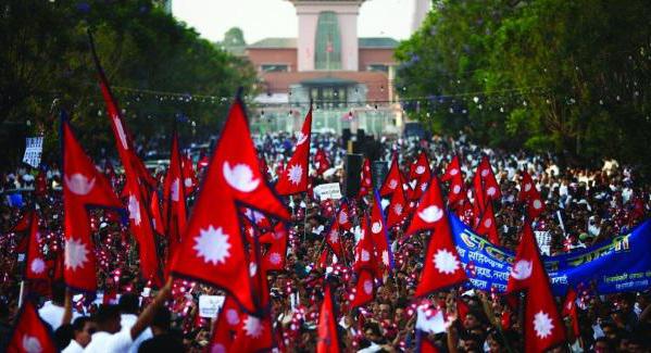
The flags of the countries of the world differ from each other not only in color or design, but also in their proportions (width and length of the flag). All flags of world states have the traditional shape of a rectangle (less often a square), with the exception of only one - Nepalese. The banner of this country is presented in the form of two equal triangles.
Flags of countries around the world vary in color. Moreover, each of the colors has its own symbolic meaning for a particular state. White typically symbolizes peace and prosperity, while green symbolizes significant natural resources.
The color black is quite interesting in heraldry. It would seem that it should be mournful. However, it is not. Black color is quite often present on the flags of African states. And there, as a rule, he symbolizes the black population of a particular country.
Designation of currencies of different countries
Everyone, of course, has their own money. How is it carried out in different countries?

This or that state currency is designated using a special sign (symbol). This can be a letter index (abbreviation), a digital code, or a special grapheme. These signs are intended to denote certain currencies in an abbreviated form, concisely and originally.
Monetary units began to be depicted with special symbols back in antiquity. Below are the graphemes of the world's most famous banknotes:
Finally...
One of the tasks of geography is an objective, comprehensive and reliable study of world states. The plan for describing the country should contain the following points: geographical location, natural conditions and resources, population, capital, administrative and political structure, economy, currency and state symbols (flag, coat of arms and anthem).
Question 1. How does the continental crust differ from the oceanic crust?
The earth's crust is continental, 30-80 km thick, and oceanic, 5-10 km thick. There are three layers in the continental crust: the upper one is sedimentary, the middle one is “granite” (close in its properties to granite) and the lower one is “basaltic” (consists mainly of basalt). The oceanic crust has only two layers - sedimentary and “basaltic”.
Question 2. Name the main forms of land relief.
The main landforms of the earth's surface can be flat, convex (hill, mountain), concave (basin, mountain valley, ravine), etc. The main landforms are plains and mountains.
Question 3. How can you determine the depths of the oceans from a physical map of the hemispheres?
Using a scale of depths and heights, colored in different colors depending on the depth.
Question 4. Using the physical map of the hemispheres, determine which continents and their parts have: a) the widest shelf; b) narrow shelf.
a) Eurasia; b) South America.
Question 5. Using a physical map of the hemispheres, name several mainland islands.
Greenland (2176 thousand sq. m.), New Guinea (785 thousand sq. m.), Kalimantan (734 thousand sq. m.), Madagascar (590 thousand sq. m.).
Question 6. Get acquainted with the map of the oceans in the atlas. Using a map of the oceans, give examples of basins and ridges on the ocean floor.
Mid-Atlantic Ridge, East Indian Ridge. Basins: Labrador, North American, Brazilian.
Question 7. Using a map of the oceans, name: a) the mid-ocean ridges of the Atlantic, Indian and Pacific oceans; b) a mid-ocean ridge that does not occupy a middle position; c) the ocean, where the mid-ocean ridge branches into two ridges; d) the widest mid-ocean ridge; e) a large island that is part of a mid-ocean ridge.
a) Mid-Atlantic Ridge. There are five mid-ocean ridges: the West Indian, Arabian-Indian, Central Indian, East Indian and Australian-Antarctic Rise. South Pacific and East Pacific rises. b) East Pacific Rise. c) Indian Ocean. d) Mid-Atlantic Ridge. d) Greenland.
Question 8. Name the three main parts of the ocean floor.
Continental shelf, ocean basins, mid-ocean ridges.
Question 9. Tell us about the topography of the transition zone, about the mid-ocean ridges.
Between the underwater edge of the continent and the ocean floor there is a zone with a very complex topography. This zone is best expressed along the eastern shores of Eurasia. It includes island arcs and special landforms - deep ocean trenches. These are long narrow depressions of the ocean floor with a depth of over 6000 m. Earthquakes often occur in the transition zone, and this is where many of the active volcanoes of our planet are located.
Mid-ocean ridges form a single mountain system on the bottom of the World Ocean with a total length of over 60 thousand km, a width of about 2000 km and a relative height of 2-4 km. In the central part of the mid-ocean ridges there is a fault, which is a gorge with steep slopes. Lava flows at the bottom of this gorge. As it hardens, it builds up the earth's crust. At mid-ocean ridges, as in the transition zone, earthquakes occur; There are active volcanoes on the slopes of the ridges.
Question 10. Based on the plan for describing the geographical location of the mountains in the appendices, describe the geographical location of the Mid-Atlantic Ridge.
1. Mid-Atlantic Ridge.
2. Located in the middle of the Atlantic Ocean.
3. Starts from the Gakkel Ridge northeast of Greenland and extends to the Bouvet Triple Junction in the south Atlantic.
Question 11. Using the plan for describing the geographical position of the plain in the appendices, compare the geographical position of the Argentine and Brazilian basins.
Argentine Basin, bottom depression in the south-west. Atlantic Ocean, between the continental slope of the South. America, the South Atlantic Ridge, the Rio Grande Plateau and the northern part of the South Antilles Ridge. Depth up to 5919 m, in a narrow trench in the south 6213 m. The soil is globigerina silt and red clay.
Brazilian Basin, a depression in the bottom of the southern Atlantic Ocean, west of the South Atlantic Ridge. The length from north to south is about 3000 km. The greatest depth is 6537 m. The soil is red clay in the east and foraminiferal silts in the west.
Question 12. Write two questions to the text about the processes that form the topography of the bottom of the World Ocean.
What processes influence the topography of the bottom of the World Ocean? What are the influences of internal processes?
QUESTIONS AND TASKS FOR REVIEW
Question 1. Draw a diagram of “Groups of rocks by origin.” Give two examples of rocks from each group.
Question 2. Give a description of the lithosphere according to plan: 1) concept; 2) structure; 3) composition; 4) characteristic natural phenomena.
1. Lithosphere – the hard (rocky) shell of the Earth.
2. Consists of the earth's crust and the upper part of the mantle. In the structure of the lithosphere, mobile regions (folded belts) and relatively stable platforms are distinguished.
3. 1- water; 2 - sedimentary layer; 3 - granite layer; 4 - basalt layer; 5 - Earth's mantle; 6 - sections of the mantle composed of rocks of increased thickness; 7 - sections of the mantle composed of rocks of reduced thickness; 8 - deep faults; 9 - volcanic cone.
4. Characteristic phenomena of the lithosphere are earthquakes and volcanic eruptions.
Question 3. Make a diagram “Types of movements of the earth’s crust.” Give examples of areas of the Earth where different types of crustal movements occur.

Question 4. Determine the geographical location of the A mountains.
The Alps, the mountain system of Europe, is the most extensive mountain system in Europe, constituting the actual core of this part of the world, covering an area of approximately 300 thousand square meters. km (without foothills - 200 thousand), lies in the middle between the equator and the North Pole, between 43° and 48° N. w. and 37° east. etc., and extends in a large semicircle from the Mediterranean coast, first to the north, and then to the east and east.
Question 5. Determine the geographical location of the East European Plain.
The East European Plain, or Russian Plain, is one of the largest plains on the globe, the second largest after the Amazon Lowland, located in the larger eastern part of Europe. It belongs to the low plains. In the north it is washed by the waters of the White and Barents seas, and in the south by the Black, Azov and Caspian seas. In the northwest it is limited by the Scandinavian mountains, in the west and southwest by the mountains of Central Europe (Sudetes, Carpathians, etc.), in the southeast by the Caucasus and Crimean mountains, in the east by the Urals and Mugodzhary. The length from north to south is about 2750 km, from west to east - about 1000 km. The area is 3 million km². The average height is about 170 m, the highest on the Kola Peninsula in the Khibiny Mountains, the lowest on the coast of the Caspian Sea.
Question 6. What groups are divided into according to absolute height: a) mountains; b) plains? How to determine the absolute height of mountains and plains from a physical map?
a) Low mountains (up to 1000 meters); Middle mountains (from 1000 to 2000 meters); High mountains (above 2000 meters);
b) Lowlands (up to 200 meters); Hills (200-500 meters); Plateau (500-1000 meters).
You can determine it by the color of the scale of depths and heights.
Question 7. Name the highest mountains: a) Eurasia; b) North America; c) South America; d) Africa. What are their prevailing heights; maximum height?
a) Himalayas, 6000-7000 m
b) Cordillera, 6000 m
c) Andes, 6000 m
d) Atlas Mountains, 4000 m.
Question 8. Tell us about how external forces influence the topography of our planet.
The relief is affected by wind, temperature, rain, and human activity. They destroy mountains, weather rocks, and form ravines.
Question 9. What is the similarity of the bottom topography of all the Earth’s oceans?
The topography of the ocean floor is made up of underwater plains and mountains located in the ocean floor.
Plan for describing the geographical location of the continent
1. Determine the geographical position of the continent: a) position in relation to the equator and the prime meridian; b) latitude and longitude of the extreme points; c) position relative to other continents, oceans, straits, bays.
2. We determine the predominant forms of relief, find out in which part of the continent they are located. We find the highest and lowest points and the amplitude of heights on the mainland
3. Determine the position in climatic zones and general climate features
4. Name and find large rivers and lakes on the physical map. We determine in which parts of the continent and in what direction the rivers flow, and to which ocean basin they belong. We determine which relief forms the lakes are associated with.
5. We determine the set and location features of natural zones.
6. We characterize the main natural resources of the continent
7. We list the largest countries of the continent.
8. What peoples inhabit the continent, in which parts of the continent is the highest density.
9. Features of economic activity of the mainland.
Ocean Description Plan
1. The name of the ocean and its size.
2. The position of the ocean relative to the equator and prime meridian, polar circles, and tropics.
3. Between which continents is the ocean located?
4. Neighborhood with other oceans.
5. Largest seas and bays.
6. Average and maximum ocean depth.
7. The most important warm and cold currents.
8. In what climatic zones is the ocean located?
9. Human use of the ocean, the most important transport routes.
10. Conclusion about the peculiarities of the geographical position of the ocean.
Travel description plan
- Tell us what the purpose of your trip is.
- Plan your travel route. Show the settlements through which your journey passed. Specify its duration.
- What type of transport did you use for your trip?
- Using a scale, calculate the approximate length and direction of your journey.
- Find out what landforms your route passed through.
- Indicate which hydrosphere objects your path passed through (rivers, lakes, seas, oceans).
- Describe the weather at the time of your trip.
- Describe the flora and fauna of the territory through which the journey took place.
River description plan
- Name of the river and its length
- On what continent is the river located and in what part of it?
- Source of the river
- Mouth of the river
- In which direction does the river flow?
- Which ocean basin does the river belong to?
- Tributaries
- The nature of the river flow
- River feeding
- River mode
- River slope
- Fall of the River
Plan for describing the country's EGP
1. Position in relation to neighboring countries.
2. Position in relation to the main land and sea transport routes.
3. Position in relation to the main fuel and raw material bases, industrial and agricultural areas.
4. Position in relation to the main distribution areas of products.
5. Change in EGP over time.
6. General conclusion about the influence of EGP on the development and location of the country’s economy.
Plan for describing the geographical location of the country
1. What maps should be used to describe a country?
2. In what part of the continent is the country located? What is the name of its capital?
3. Features of the relief (general character of the surface, main forms of relief and distribution of heights). Mineral resources of the country.
4. Climatic conditions in different parts of the country (climatic zones, average temperatures in July and January, annual precipitation). Differences by territory and by season.
5. Large rivers and lakes.
6. Natural areas and their main features.
7. Peoples inhabiting the country. Their main activities.
When using materials from this site - and placing a banner is MANDATORY!!!
Mountain characteristics plan
1. Geographical location.
3. Length of ridges (km).
4. Predominant height.
5. Maximum height (vertex coordinates).
6. age, origin.
Plains Characteristics Plan
1.Geographical location.
2. Borders of the plain.
3. Formation of plains.
5. Length from west to east and from north to south (km).
Ocean Characterization Plan
1.Geographical location.
2.Area. A place among other oceans.
3. Features of the bottom topography.
4. Predominant and greatest depths.
5.Ocean currents.
6. Transport sea routes.
Sea characteristics plan
1.Geographical location.
2. Internal or peripheral.
3.Outline of the banks and area.
4. Islands and peninsulas.
5.The greatest and predominant depth.
River characteristics plan
1.Geographical location.
2.Where does it begin (source).
4.Where it flows (mouth).
5. Dependence of the direction and nature of the flow on the relief.
Lake characteristics plan
1.Geographical location.
2. How it was formed.
3. Greatest depth.
4. Salinity.
5.Drain or drainless.
6.The nature of the shores.
Weather Characteristics Plan
1.Name of the month, season of the year.
2. The height of the Sun above the horizon (for each season).
3.Length of the day.
4.Average temperature.
5. Prevailing winds.
6.Amount and types of precipitation.
Map characteristics plan
1.type of map by territory coverage.
2.View of the map by scale.
3.Type of map by content.
4.Purpose of the card.
Plan for describing the geographical location of the continent
1. The area of the continent and its place among other continents.
2. The location of the continent relative to the equator, the tropics (arctic circles), the prime and 180th meridians.
3. Extreme points of the continent, coordinates. The length of the continent in degrees and kilometers from north to south and from west to east.
4. The nature of the coastline.
5.Location in climatic zones.
6.Oceans, seas washing the continent.
7. Location relative to other continents.
Plan for the characteristics of the territory's relief
1. General character of the surface. General patterns.
2. Location of relief forms on the surface under study.
Landform characteristics plan
1. Location on the mainland.
2. Approximate area and its comparison with the area of the mainland.
3. Maximum, minimum and prevailing heights.
4. Origin (processes)
Climate Characteristics Plan
1. Geographical location.
2. Type of climate (climatic zone and region).
3. Climate-forming factors.
4. Average temperatures in January and July, temperature maximums and minimums.
5. Amount of precipitation and its distribution throughout the year.
6. Prevailing winds (by season).
Plan for characterizing climate diagrams.
1.Location (mainland, part of it).
2.Annual variation of temperatures.
3.Amount of precipitation. Distribution of precipitation by month.
4. Characteristic type of climate (climatic zone and regions).
River characteristics plan
1.Location on the mainland relative to other landforms.
2. Source location.
5. The nature of the current (plain or mountainous).
4.What kind of terrain does it flow through?
6. Change in flow by season.
7. River tributaries.
8. Location of the mouth.
9. Pattern of human use.
10. Environmental problems.
Natural area characterization plan
1.Geographical location, borders.
3. Animal world
4. Climate.
6. Vegetation.
7. Inland waters.
Continental population characteristics plan
1. Peoples inhabiting this territory.
2. Distribution of the population across the continent (densely populated areas and less populated areas, reasons).
3. Average density (for the continent as a whole and for individual regions).
Country characteristics plan
1.Geographical location, borders, border states, capitals.
2. Features of the relief (general character of the surface, minerals).
3. Climatic conditions (climatic zones, average temperatures in January and July, annual precipitation).
4. Inland waters (large rivers, lakes, reservoirs, etc.).
5. Natural areas and their features (soils, vegetation, fauna).
7. Population (main races, peoples and their economic activities).
Plan for characterizing the geographical position of the ocean
1. Location relative to the hemispheres, the equator, the tropics, the prime meridian and the 180th meridian.
2. Washed continents.
3. Bordering oceans (straits).
4. Location in climatic zones.
Sea characteristics plan
1.Which ocean does it belong to?
2.Which parts of the continent does it wash?
3. Features of the coastline.
4. Sea depth, salinity.
5. Freezing.
6. Commercial significance.
Plan for the characteristics of the natural-territorial complex (ptk)
1. geographical location.
2. geological structure and minerals.
4. Climate (climatic zones and regions, average temperatures in January and July, temperature range, average annual precipitation, humidification coefficient, annual sum of temperatures above + 10 C, the possibility of natural conditions for agricultural use of the territory).
6 Vegetation.
7. Animal world
8 Environmental problems.
Natural resource characterization plan
1. total reserves and concentration per unit area).
2. Quality, composition.
3. Conditions of occurrence (depth, thickness of layers).
4. Combination with other types of minerals, the possibility of their joint use.
5. Development of the territory.
6. Transport possibilities.
7. Conclusion about rational use taking into account the impact on the environment.
Population Characteristics Plan
1. Number. Natural and mechanical growth.
2.National composition.
3. Density, features of population distribution.
Map characteristics plan
- What is the map in terms of territory coverage, scale, content?
- What knowledge can be gained by working with this map?
Plan for describing the geographical location of the continent
- Determine how the continent is located relative to the equator, the tropics (arctic circles) and the prime meridian.
- Find the extreme points of the continent, determine their coordinates and the length of the continent in degrees and kilometers from north to south and from west to east.
- In what climate zones is the continent located?
- Determine which oceans and seas wash the continent.
- How is the continent located relative to other continents?
Plan for describing the relief of the territory
- What is the general nature of the surface? How can this be explained?
- How are the landforms located in the study area?
- What are the highest and most dominant altitudes?
Landform description plan
- Determine which cards are needed for the description.
- In what part of the continent is the landform located?
- In what direction does it stretch?
- What are the approximate dimensions?
- What are the highest altitudes, prevailing altitudes?
- If possible, find out what the origin of the landform is.
Climate description plan
- In what climate zone and in what region is the territory located?
- Average temperatures in July and January. In what direction are they changing and why?
- Prevailing winds (by season).
- Annual precipitation and its regime. How can we explain the difference in precipitation?
Working with climate diagrams
- Look carefully at all the symbols on the diagram. (The months of the year, after one, are indicated by letters.) What can you learn from it?
- Find out the annual temperature range. What are the average temperatures in July and January? What is the annual temperature range?
- What amount of precipitation is typical for this climate type? What is the precipitation pattern throughout the year?
- Make a conclusion about the type of climate.
River description plan
- In what part of the continent does it flow?
- Where does it start? Where does it flow?
- In what direction does it flow?
- Explain the dependence of the nature of the flow on the relief.
- Identify the river's food sources.
- What is the river regime and how does it depend on climate?
Natural area description plan
- Geographical location of the zone.
- Climatic conditions.
- Soils.
- Vegetation.
- Animal world.
When describing a natural area, reveal the relationships between the components of its nature.
Continental Population Plan(according to the map “Population density and peoples”)
- What peoples inhabit the study area?
- Which parts of the mainland or other territory are particularly densely populated? What is the average population density?
- In what places is the population sparse? What is the lowest density?
Country description plan
- What maps should be used when describing a country?
- In what part of the continent is the country located? What is the name of its capital?
- Features of the relief (general character of the surface, main forms of relief and distribution of heights). Mineral resources of the country.
- Climatic conditions in different parts of the country (climatic zones, average temperatures in July and January, annual precipitation). Differences by territory and by season.
- Large rivers and lakes.
- Natural areas and their main features.
- The peoples inhabiting the country. Their main activities.
Plan for describing the geographical position of the ocean
- Indicate between which continents the ocean is located. What other oceans is it connected to?
- How is the ocean located relative to the equator, tropics, polar circles and prime meridian?
- In what climate zones is the ocean located?
How to compare correctly
- First, identify your comparison goals. What is more important to learn - similarities or differences? Maybe both?
- Select features for comparison.
- Establish similarities and differences.
- Draw a conclusion and explain the reasons for the similarities and differences.
Related posts:
 Subjects of obzh classes. What is life safety at school? Program and study of life safety at school. Design of information stands
 South America Geography Test 7
 Literacy lesson notes
 Plans for describing geographical objects material (geography) on the topic
 The cost of the full-time immersion course includes


