How to check if rings are buried or not. Groundwater Depth: Determination Methods
- Varieties of depth
- Level determination methods
- Modern option
- Folk ways
Any person acquiring a land plot plans to build residential or utility facilities on it. Regardless of what will be on the site - a residential building, a pool, a well, a cellar, a warehouse, etc., - knowledge of the depth of the groundwater is of great importance. The methods of construction and the choice of materials will depend on this. Before you determine, you need to know what they are.
Varieties of depth
Any encyclopedia or reference will give the following description of the depth of groundwater: this is the highest underground aquifer. The formation of a layer is facilitated by precipitation and the proximity of water bodies - lakes or rivers. Depending on the time of year, the GWP may vary. So, in hot summers, the soil waters will lie much deeper than during rains or snowmelt.
The low location of groundwater, in which the layer is at a depth of 2 m, is not dangerous for the foundations of buildings. In this case, you can choose almost any foundation for the house and not equip reinforced waterproofing. If groundwater is located in close proximity to the soil level, the soil has a high degree of moisture, which, in turn, affects its bearing capacity.
On a site where there is a high level of soil water occurrence, it is much more difficult to build houses with deep basements and ground floors, to equip pools and cellars. In addition, it is more demanding to approach the choice of plants that will make up the landscape design of the site, because not all flowers, bushes and vegetable crops can grow on moist soil.
With a high occurrence of groundwater, the site should be equipped with a complete drainage system, but even it is not always able to cope with excess moisture. So that the indicator of the occurrence of groundwater does not turn out to be an unpleasant surprise, it is necessary to conduct research before starting construction work.
Back to the table of contents
Level determination methods
Despite the fact that the process of determining the level of occurrence of water under the soil without the participation of surveyors looks quite complicated, it can be successfully completed on its own. The presence of aquifers was also determined by our ancestors when they built their dwellings and dug wells, so today there are several ways to determine the level of groundwater. They can be divided into modern and folk.
Back to the table of contents
Modern option
To use the modern method will require the following tools:
- garden drill at least 2 m long;
- a long metal rod on which marks will be made indicating centimeters.
The algorithm of actions is quite simple: you need to drill a well for the full length of the drill and leave it alone for 24 hours. During this time, moisture will accumulate in the hole. It will be necessary to lower a metal rod into the well and thus determine the level of groundwater. A mark on the rod will show how deep the liquid is. Then you need to make simple calculations and find out the depth of moisture.
For example, the rod became wet to a mark of 10 cm. Knowing the depth of the pit, you can calculate the depth of the water: 200 cm - 10 cm \u003d 190 cm. Checking the liquid level must be done within a few days. If the indicators do not change, this number should be considered a mirror of soil water. In the case when it is necessary to know the level of occurrence deeper than 2 m, you can use a spoon drill, which can make the well to a depth of 5 m. Further, the process is similar to the above.
This is how you can find out what level of flooding of the foundation of the house should be expected when snow melts.
Most houses have a centralized water supply. But due to the remoteness from the settlement or for other reasons, in some country cottages, it is not at the dachas. The owners have to drill a well or equip a well.
To determine the horizon of the source, you have to resort to the help of a professional. His services are expensive. The depth of groundwater can be set independently. At the same time, it will be possible to significantly save the family budget for the arrangement of the water supply system. To do this, several simple approaches are used. Before you begin, you need to consider the entire procedure in detail.
Groundwater Type
The depth of the groundwater level is different. The type of source depends on this indicator. It is taken into account when conducting a water supply system. The layer closest to the surface is called the tip. It is located at a depth of 2-3 m. This source is applicable only for technical purposes.
Followed by a free surface. There are also inter-layer non-pressure and pressure artesian sources. The cleanest, drinkable is the last variety. Chemical composition and quality are the highest among all sources. A layer of water can pass in sand, or in gravel.
Groundwater Features
Before determining the depth of groundwater, it is necessary to learn about their features. First of all, the type of terrain affects their location. In the steppe, where the surface is flat, the layers run evenly. At any point, their depth is the same. 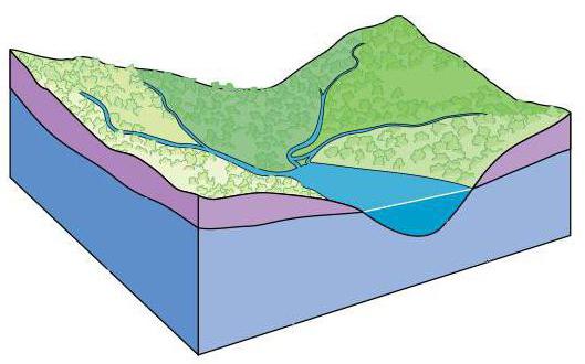
But in the presence of bumps, water slides are also located flexibly. Experts recommend taking into account such features of the relief when creating a well. If you need water for technical purposes, you can use the first layer. He comes closer to the surface than others.
For drinking purposes, it is necessary to use water from at least the second layer. If the terrain is hilly, it is better to drill a well on a hill. In this case, the soil layer will better filter out such water.
In swampy areas, groundwater can approach the surface at a depth of only 1 m. When developing a well, you need to be prepared for this.
Groundwater in the Moscow region
Before the owners of their own homes should inquire about the features of the layers of underground sources. For example, the depth of groundwater in the Moscow region is characterized by heterogeneity.
5 main layers stand out here. All of them are unevenly located and have different capacities. The first three layers are characterized by low pressure. They are used for technical purposes. Water discharge occurs in small streams and rivers. These groundwater replenishes in the spring when snow begins to melt. 
In the dolomite and limestone rocks, two lower layers occur. The depth of their occurrence is about 100 m. It is these sources that are suitable for drinking purposes. In the Moscow region, central water supply was laid precisely from these sources.
Preparation for measurement
Moistening conditions and the depth of groundwater are rather closely related. When planning to take measurements, you need to choose the right time. In this case, there should be no drought, nor prolonged rains. All weather conditions affect the measurement result. 
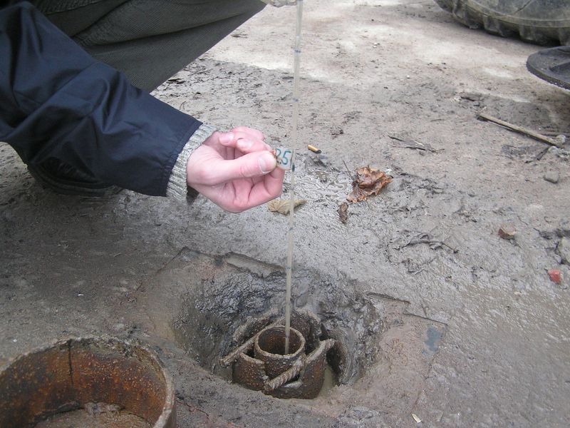
To determine the depth of groundwater, you must use one of the simplest methods. To do this, you need to prepare all the tools and materials at hand. Of the tools required ordinary drill, tape measure. It is also necessary to prepare a long rope.
In addition to tools, certain chemical elements are needed. This is sulfur, and copper sulfate. For different methods, one or another improvised means will be required.
Drilling
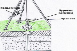
Determining the depth of groundwater is possible using several methods. The most reliable of them is drilling. At the same time, it is possible to determine exactly how deep the underground source is, whether there are significant obstacles in the form of stones on the way to it. 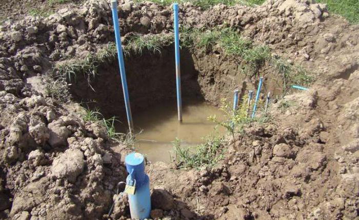
For work, a normal factory drill is suitable. If desired, additional blades are welded on its blades. The tool crashes into soft ground. He is taken to the surface with the earth. To soften the soil, it is watered with water.
Using a threaded, sleeve connection, the drill is fastened with pipes to go deep to the desired level. Next, with the help of a rope make measurements. The well should be 0.5-1 m deeper than the paper attached to the rope and check at what level it gets wet.
Chemical application
If you don’t want to drill a well, there is an easier way to find out the depth of groundwater. To do this, shovel a hole in the intended place. It can be about 0.5 m deep. It requires the installation of a clay pot.
Quicklime, sulfur and copper sulphate are mixed in a vessel in equal proportions. Next, the pit is buried and left for a day. After that, the pot is brought to the surface and weighed. The heavier it became, the closer the groundwater came to the surface. This method is not accurate enough, but it has been used since the earliest times. Only now it has been improved.
Barometer
Another reliable way to determine what is the depth of groundwater in a given area is to use a barometer. However, it should be noted that its use requires the presence of a reservoir in the district.
If there is one, you can begin to measure. Each barometer division corresponds to 1 m of depth. First, with the device you need to go to the pond. Here the barometer readings are recorded.
Then they move away from the reservoir to the intended place. The readings of the device are marked. The difference between the first and second measurements is approximately equal to the depth of the underground source. 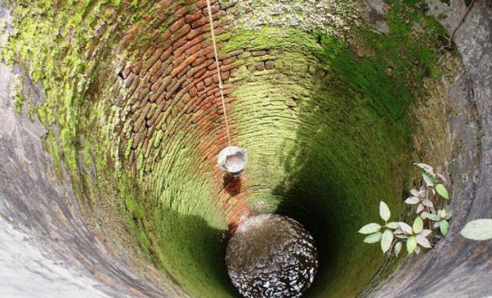
This method is also not very accurate. The error distorts the real picture. But the general principle can be understood.
Folk way
The depth of groundwater can be determined by folk methods. First of all, you need to pay attention to vegetation. Where the source comes close to the surface, it is greener, brighter. In such places reeds, ivy, forget-me-not and other moisture-loving representatives of the flora love to grow.
A popular approach involves the following. Wash and dry the wool well in a soapy solution. At the proposed site for the experiment, vegetation is removed.
On the ground lay wool. A raw egg is laid on it and everything is covered with a frying pan. In the morning, evaluate the result of the experiment. If the egg and the litter of wool are covered with dew drops, then the water comes close to the surface. But you need to carry out such a procedure in dry weather.
Having examined how the depth of groundwater is determined, you can independently measure. Depending on the method chosen, you can get a more accurate or approximate result. All work can be done independently. This will save a lot of family budget.
Determining the occurrence of groundwater is a rather serious question, because it is encountered when exploring an existing site. So, for summer residents, this is a way to get water supply, and builders are the first step in designing a structure.
It is important for the owners of the plots to find a source of drinking water supply, so they equip the wells or the capture. For its proper construction, you need to choose a suitable place, which in turn depends on groundwater. They are located in the first aquifer, therefore, are the most affordable source of fluid. In addition, this information is used when planting crops, because the chemical composition of the soil can change from groundwater.
The value of groundwater
It is important to determine the level of underground sources in time, because they are fraught with serious problems. If we consider the issue from the point of view of summer residents, the incoming water has an unknown composition, respectively, can negatively affect plants. In addition to the fact that cultures die from oversaturation with moisture, impurities in the liquid also worsen the state of the root system.
Well problems can also begin, because water seeps through even the smallest crevices. If a cesspool or toilet is located nearby, it will become impossible to drink this water. Even for commercial use, it is not useful, because some types of groundwater are characterized by high salt content. Accordingly, you can not drink animals or use for washing. 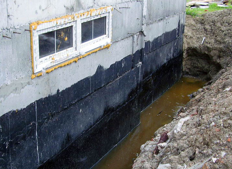
As for buildings, everyone knows the harmful effects of moisture on the foundation, so lowering the groundwater level is often required. In addition, the high occurrence of underground sources leads to problems in arranging a cellar or basement, a viewing hole in a garage or sewer. But all issues are resolved, there are many ways to remove excess moisture.
You can not talk exclusively about the harm of underground sources, because the low level of groundwater also has its negative sides. The main problem arises when you want to equip water supply on the site, you always have to contact specialists.
Layering
Before the construction of any design, the site is examined, the relief, soil composition and the level of groundwater occurrence are determined. The design of the building depends on it, or rather, the calculation of the foundation. So, the amount of moisture in the soil varies depending on the season and location near lakes or rivers, so all terrain features are important in the process.
Before determining the level of groundwater, it is worth considering the types of underground sources, there is a separation:
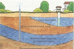
- high water formed due to precipitation and melt snow. It refers to surface groundwater. As a rule, this layer goes at a level of 1-2 m below the surface of the earth. Their volume is small and fully corresponds to the amount of precipitation. At the same time, the use of this liquid without preliminary treatment is impossible due to its chemical composition and impurities;
- non-pressure water - mixing of surface type with liquid from lakes and rivers. They have no pressure due to natural filtration through loams and sandy loams. According to sanitary standards, it is practically safe, while it has good organoleptic characteristics;
- artesian - the cleanest and safest waters, characterized by optimal composition. This species is appreciated for its beneficial properties and readiness for use without any processing. This layer is located between two thrust layers.
To equip the well, it is necessary to break through the upper layer, then water under pressure will rise up.
Indicators of occurrence of sources
The groundwater level is determined by the pressureless layer, because it is it that gives builders the most trouble. It is possible to determine the proximity of water without the involvement of specialists, it is enough to inspect the area carefully. Typically, a groundwater mirror goes at a depth of 2-20 m from the surface, so a swampy area indicates the location of water at a level not lower than 1 m. Filled shallow depressions indicate a water level above the surface of the earth.
Natural signs
In nature, there are a number of signs that are worth paying attention to:
- plants on the site can tell not only about the presence, but also about the depth of groundwater. The proximity of the aquifer is characterized by the presence of moisture-loving crops. For example, if groundwater is located at a depth of about 3 m, then on the site you can find horse sorrel, hemlock, coltsfoot, reeds. On the territory with an aquifer depth of 5 m there is wormwood and licorice. Judging by the trees, the declining willow, birch or alder indicate the presence of a water vein. At the same time, lilac, cotoneaster, grapes and juniper do not tolerate waterlogging, respectively, in terms of appearance, they determine the distance to the liquid;
- the behavior of animals can also be used to judge the depth of groundwater. For example, cats love places above water veins, while dogs prefer dry soil. Everyone knows that midges and mosquitoes are attracted by moisture, whole columns of insects can be found after sunset in areas with a high occurrence of the water layer. Red ants and mice also prefer dry soil, therefore, in their absence, it can be argued that the aquifer is located near the surface of the earth;
- if we consider folk signs, then you should pay attention to morning dew, its abundance indicates the proximity of water. Evening fog is also an indicator of high groundwater, but only in the absence of a nearby body of water.
Determination methods
To detect groundwater, at a level of 3-5 m, it is necessary to drill a small diameter well. For this, they turn to specialists or arrange themselves on their own using a garden drill. A day after drilling, check the water level in the well, if it does not change for several days, then it is taken as a mirror of groundwater.
Topographic survey helps to navigate the terrain, which will reveal the highest and lowest elevation marks. As you know, in the most elevated areas there is a high level of groundwater, respectively, in the depressions and lowlands, the indicator decreases. Specialists are engaged in the creation of a topographic map, although you can do everything yourself, for this you will need improvised tools. But she will not give a complete picture of the waters.
It is only possible to accurately determine the depth of groundwater using wells, but seasonal variations can be estimated from the marks in the wells. Traces of water always remain noticeable on concrete - this is how the level indicators at the moment, the highest and lowest indicators, are recognized.
Folk way
There are also folk remedies for resolving the issue on which our great-grandfathers relied. For this method, a bundle of fat-free wool, a freshly laid egg and a clay pot were taken. In a place where it was required to determine the level of groundwater, a layer of turf was removed. Then wool was laid on the cleared land, an egg was laid on top and covered with a pot. They covered everything with the removed turf, and at sunrise examined the result. If the egg was wet, then the aquifer is close. With a wet coat, but a dry egg, it is worth considering that the water is deep. In the absence of underground sources, the components of the experiment remain without moisture. This method is reliable and proven, therefore, is still popular.
If during the study of the territory groundwater was not found at a depth of 3-5 m, then they are not dangerous when erecting the foundation of structures. But if it is planned to equip a well or a well on a site, then it is necessary to know the surface level of underground sources. In this case, it is worth considering the type and composition of the soil, for which they turn to geologists.
In the following video, you can see a fairly effective way to determine the level of groundwater: